File:Athabasca Oil Sands map.png
Jump to navigation
Jump to search

Size of this preview: 410 × 599 pixels. Other resolution: 1,200 × 1,753 pixels.
Original file (1,200 × 1,753 pixels, file size: 611 KB, MIME type: image/png)
Summary
| Description |
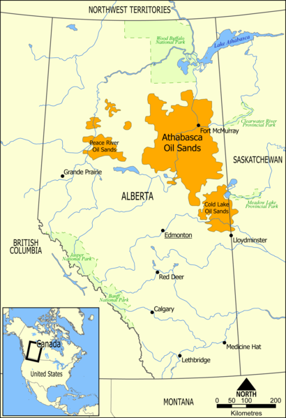
English: This map shows the extent of the oil sands in Alberta, Canada. The three oil sand deposits are known as the Athabasca Oil Sands, the Cold Lake Oil Sands, and the Peace River Oil Sands. |
| Date | |
| Source | Own work |
| Author | NormanEinstein |
| Other versions |
Derivative works of this file: Athabasca oil sand mining map 2011.jpg: |
Licensing
| I, the copyright holder of this work, release this work into the public domain. This applies worldwide. In some countries this may not be legally possible; if so: I grant anyone the right to use this work for any purpose, without any conditions, unless such conditions are required by law. |
File history
Click on a date/time to view the file as it appeared at that time.
| Date/Time | Thumbnail | Dimensions | User | Comment | |
|---|---|---|---|---|---|
| current | 11:49, 10 May 2006 | | 1,200 × 1,753 (611 KB) | imagescommonswiki>NormanEinstein | This map shows the extent of the oils sands in Alberta, Canada. The three oil sand deposits are known as the Athabasca Oil Sands, the Cold Lake Oil Sands, and the Peace River Oil Sands. Created by NormanEinstein, May 10, 2006. {{GFDL-self}} [[Category: |
File usage
The following file is a duplicate of this file (more details):
- File:Athabasca Oil Sands map.png from Wikimedia Commons
The following page uses this file: