File:KhSh9colkey.png

From Citizendium
Jump to navigation Jump to search

Original file(1,872 × 1,800 pixels, file size: 2.99 MB, MIME type: image/png)

This file is from a shared repository and may be used by other projects. The description on its file description page there is shown below.

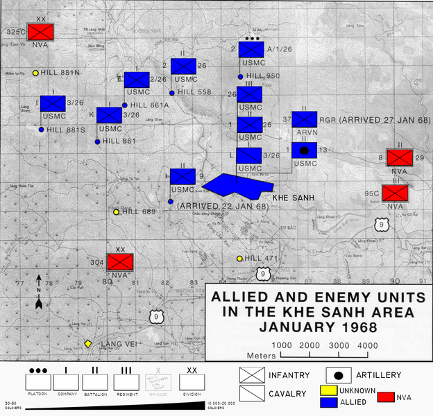
Description Map of area surrounding Khe Sanh during the Tet Offensive modified to include color and explanation of map symbols
Date Original 1968 modified 02:36, 6 December 2007 (UTC)
Source Original map sourced from Schulimson, Jack (1997) US Marines in Vietnam: 1968, Washington, D.C.: Marine Corps History and Museums Division, p. 71 .
Author USMC modified by Anynobody 02:36, 6 December 2007 (UTC)
Permission
(Reusing this file)
Public Domain
Other versions w:Image:KhSh9.jpg
Public domain
This file is a work of a United States Marine or employee, taken or made as part of that person's official duties. As a work of the U.S. federal government, it is in the public domain.

العربية  বাংলা  català  Deutsch  English  español  français  magyar  italiano  日本語  македонски  മലയാളം  မြန်မာဘာသာ  Nederlands  português  русский  sicilianu  slovenščina  svenska  Türkçe  українська  Tiếng Việt  中文(简体)  中文(繁體)  +/−

Captions

Add a one-line explanation of what this file represents

Items portrayed in this file

depicts

File history

Click on a date/time to view the file as it appeared at that time.

Date/TimeThumbnailDimensionsUserComment
current20:36, 5 December 2007Thumbnail for version as of 20:36, 5 December 20071,872 × 1,800 (2.99 MB)imagescommonswiki>Anynobody~commonswiki{{Information |Description=Map of area surrounding Khe Sanh during the Tet Offensive modified to include color and explanation of map symbols |Source=USMC |Date=Original 1968 modified ~~~~~ |Author=[[w:USMC|US

The following file is a duplicate of this file (more details):

There are no pages that use this file.