File:444px-Baghdad etm 2003092 lrg.jpg: Difference between revisions
Jump to navigation
Jump to search
imported>Charles Sandberg No edit summary |
imported>Caesar Schinas m (Replace Template:Information with Template:Image_Details) |
||
| Line 1: | Line 1: | ||
{{Image_Details | |||
| description = This image shows the city of Baghdad, the capital of Iraq. The dark smoke plumes are from pits of burning oil arrayed in a ring around the center of the city, a tactic used to stall and confuse invaders since medieval times. Baghdad Airport can be seen southwest of the city, just outside the smoke. | |||
This image was acquired by Landsat 7?s Enhanced Thematic Mapper plus (ETM+) sensor on April 2, 2003. Image provided by the USGS EROS Data Center Satellite Systems Branch. | |||
| author = Landsat 7?s Enhanced Thematic Mapper plus (ETM+) sensor | |||
| copyright = Landsat 7?s Enhanced Thematic Mapper plus (ETM+) sensor | |||
| source = http://earthobservatory.nasa.gov/NaturalHazards/natural_hazards_v2.php3?img_id=10149 | |||
| date-created = April 2, 2003 | |||
| pub-country = | |||
| notes = | |||
| versions = | |||
}} | |||
== Licensing/Copyright status == | |||
This file is in the public domain because it was created by NASA. NASA copyright policy states that "NASA material is not protected by copyright unless noted". | |||
Revision as of 03:08, 22 June 2009
| Title / Description
|
This image shows the city of Baghdad, the capital of Iraq. The dark smoke plumes are from pits of burning oil arrayed in a ring around the center of the city, a tactic used to stall and confuse invaders since medieval times. Baghdad Airport can be seen southwest of the city, just outside the smoke.
This image was acquired by Landsat 7?s Enhanced Thematic Mapper plus (ETM+) sensor on April 2, 2003. Image provided by the USGS EROS Data Center Satellite Systems Branch. |
|---|---|
| Author(s)
|
Landsat 7?s Enhanced Thematic Mapper plus (ETM+) sensor |
| Copyright holder
|
Landsat 7?s Enhanced Thematic Mapper plus (ETM+) sensor See below for license/re-use information. |
| Source
|
http://earthobservatory.nasa.gov/NaturalHazards/natural_hazards_v2.php3?img_id=10149 |
| Date created
|
April 2, 2003 |
| Country of first publication
|
Please edit this page and add the country of first publication, or note that it is unknown. |
| Notes
|
You can edit this page and add notes here which may be useful to people who wish to re-use this media. |
| Other versions
|
If there are other versions of this media on CZ, please list them here. |
| Using this image on CZ
|
, then copy the code below to add this image to a Citizendium article, changing the size, alignment, and caption as necessary.
|
Image issue? Contact us via the email below.
Please send email to manager A T citizendium.org .
Licensing/Copyright status
This file is in the public domain because it was created by NASA. NASA copyright policy states that "NASA material is not protected by copyright unless noted".
File history
Click on a date/time to view the file as it appeared at that time.
| Date/Time | Thumbnail | Dimensions | User | Comment | |
|---|---|---|---|---|---|
| current | 18:53, 11 March 2022 | 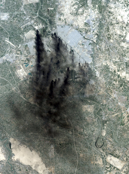 | 444 × 599 (106 KB) | Maintenance script (talk | contribs) | == Summary == Importing file |
You cannot overwrite this file.
File usage
The following page uses this file: