Sea of Japan/Gallery

From Citizendium
< Sea of Japan
Revision as of 17:58, 18 December 2008 by imported>Chunbum Park
(diff) ← Older revision | Latest revision (diff) | Newer revision → (diff)
Jump to navigation Jump to search
This article is a stub and thus not approved.
Main Article
Discussion
Related Articles  [?]
Bibliography  [?]
External Links  [?]
Citable Version  [?]
Gallery [?]
 
A collection of images about Sea of Japan.

Maps with "East Sea"

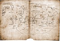
Vinland Map, a 15th-century redrawing of a 13th-century original, is the first western map to refer to the sea as the "East Sea" ("mare Occeanum Orientale").
PD Image
Vinland Map, a 15th-century redrawing of a 13th-century original, is the first western map to refer to the sea as the "East Sea" ("mare Occeanum Orientale").
"Minor Eastern Sea" in a early 18th-century German map
PD Image
"Minor Eastern Sea" in a early 18th-century German map

Maps with "Sea of Korea"

An early 17th-century Portuguese map; the first instance of "Sea of Korea ("Mar Coria") appearing on a map.
PD Image
An early 17th-century Portuguese map; the first instance of "Sea of Korea ("Mar Coria") appearing on a map.
"Sea of Joseon" in a late 19th-century Japanese map.
PD Image
"Sea of Joseon" in a late 19th-century Japanese map.
"Sea of Korea" in a mid 18th-century French map.
PD Image
"Sea of Korea" in a mid 18th-century French map.

Maps with "Sea of Japan"

An early 17th-century map drawn by an Italian missionary in China. It is the first map in which the term "Sea of Japan" appears.
PD Image
An early 17th-century map drawn by an Italian missionary in China. It is the first map in which the term "Sea of Japan" appears.
"Sea of Japan" in a mid 19th-century British map.
PD Image
"Sea of Japan" in a mid 19th-century British map.