File:DBP-Area Map.png
Jump to navigation
Jump to search

Size of this preview: 607 × 600 pixels. Other resolution: 736 × 727 pixels.
Original file (736 × 727 pixels, file size: 160 KB, MIME type: image/png)
| Title / Description
|
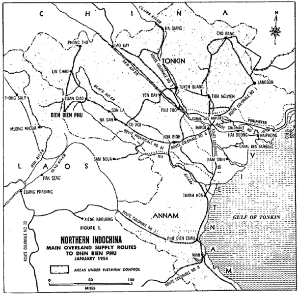
Dien Bien Phu region |
|---|---|
| Author(s)
|
Normal E. Martin, U.S. Army |
| Copyright holder
|
USG, none claimed See below for license/re-use information. |
| Source
|
http://calldp.leavenworth.army.mil/eng_mr/txts/VOL36/00000006/art3.pdf |
| Date created
|
June 1956 |
| Country of first publication
|
US |
| Notes
|
Dien Bien Phu and the future of Airborne Operations, Military Review, |
| Other versions
|
If there are other versions of this media on CZ, please list them here. |
| Using this image on CZ
|
, then copy the code below to add this image to a Citizendium article, changing the size, alignment, and caption as necessary.
|
Image issue? Contact us via the email below.
Please send email to manager A T citizendium.org .
File history
Click on a date/time to view the file as it appeared at that time.
| Date/Time | Thumbnail | Dimensions | User | Comment | |
|---|---|---|---|---|---|
| current | 18:58, 11 March 2022 | | 736 × 727 (160 KB) | Maintenance script (talk | contribs) | == Summary == Importing file |
You cannot overwrite this file.
File usage
The following page uses this file: